
🚀 宇宙の記憶・カレンダー検索
🚀 象徴的な写真:
APOD第1回
🚀 創造の柱
🚀 スピリット火星着陸
🚀 ハッブル超深宇宙
🚀 地球へようこそ|ブルー・マーブル
🚀 エンケラドス
🚀 ベテルギウス
🚀 火星着陸
🚀 青い夕焼け
🚀 冥王星のハート
🚀 皆既日食
🚀 アースライズ再構築
🚀 ブラックホール
🚀 ウェッブ初画像
🚀 アポロ11着陸
APOD30周年(2025年6月16日)
火星のシャープ山付近の層状岩石
Layered Rocks near Mount Sharp on Mars
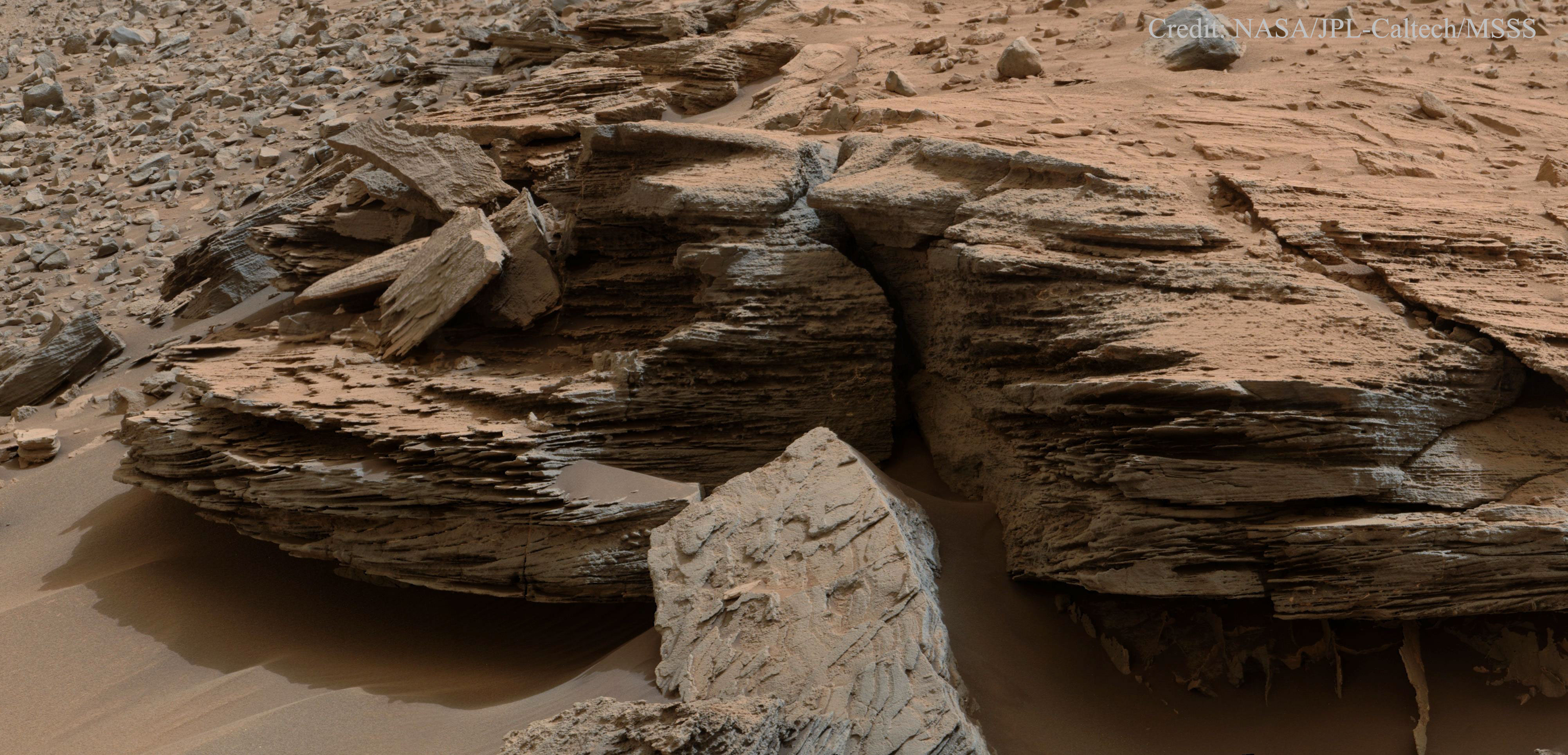
これらの火星の岩石が層状になった原因は何でしょうか?有力な仮説は、1000万年以上もの間、蒸発と再充填を繰り返してきた古代の火星の湖が、数十億年もの間、干上がって水がなくなったというものです。昨年11月に探査車キュリオシティが撮影したこの画像には、シャープ山の麓にあるパランプ・ヒルズの露頭の一部である、幅1メートルのホエール・ロックが写っています。画像には、砂の波によって形成されたと考えられる斜交層理(傾斜した層を持つ岩石)もはっきりと写っています。キュリオシティは、高さ5.5キロメートルのシャープ山を転がり回り、登り続ける中で、このような層状の岩石を次々と発見しています。
原文(English)
What caused these Martian rocks to be layered? The leading hypothesis is an ancient Martian lake that kept evaporating and refilling over 10 million years -- but has now remained dry and empty of water for billions of years. The featured image, taken last November by the robotic Curiosity rover, shows one-meter wide Whale Rock which is part of the Pahrump Hills outcrop at the base of Mount Sharp. Also evident in the image is cross-bedding -- rock with angled layers -- which were likely facilitated by waves of sand. Curiosity continues to find many layered rocks like this as it continues to roll around and up 5.5-km high Mount Sharp.
\ この感動を宇宙仲間にシェア /
宇宙をXでシェア
© NASA / APOD