
🚀 宇宙の記憶・カレンダー検索
🚀 象徴的な写真:
APOD第1回
🚀 創造の柱
🚀 スピリット火星着陸
🚀 ハッブル超深宇宙
🚀 地球へようこそ|ブルー・マーブル
🚀 エンケラドス
🚀 ベテルギウス
🚀 火星着陸
🚀 青い夕焼け
🚀 冥王星のハート
🚀 皆既日食
🚀 アースライズ再構築
🚀 ブラックホール
🚀 ウェッブ初画像
🚀 アポロ11着陸
APOD30周年(2025年6月16日)
地球上の湖水効果雪
Lake Effect Snow on Earth
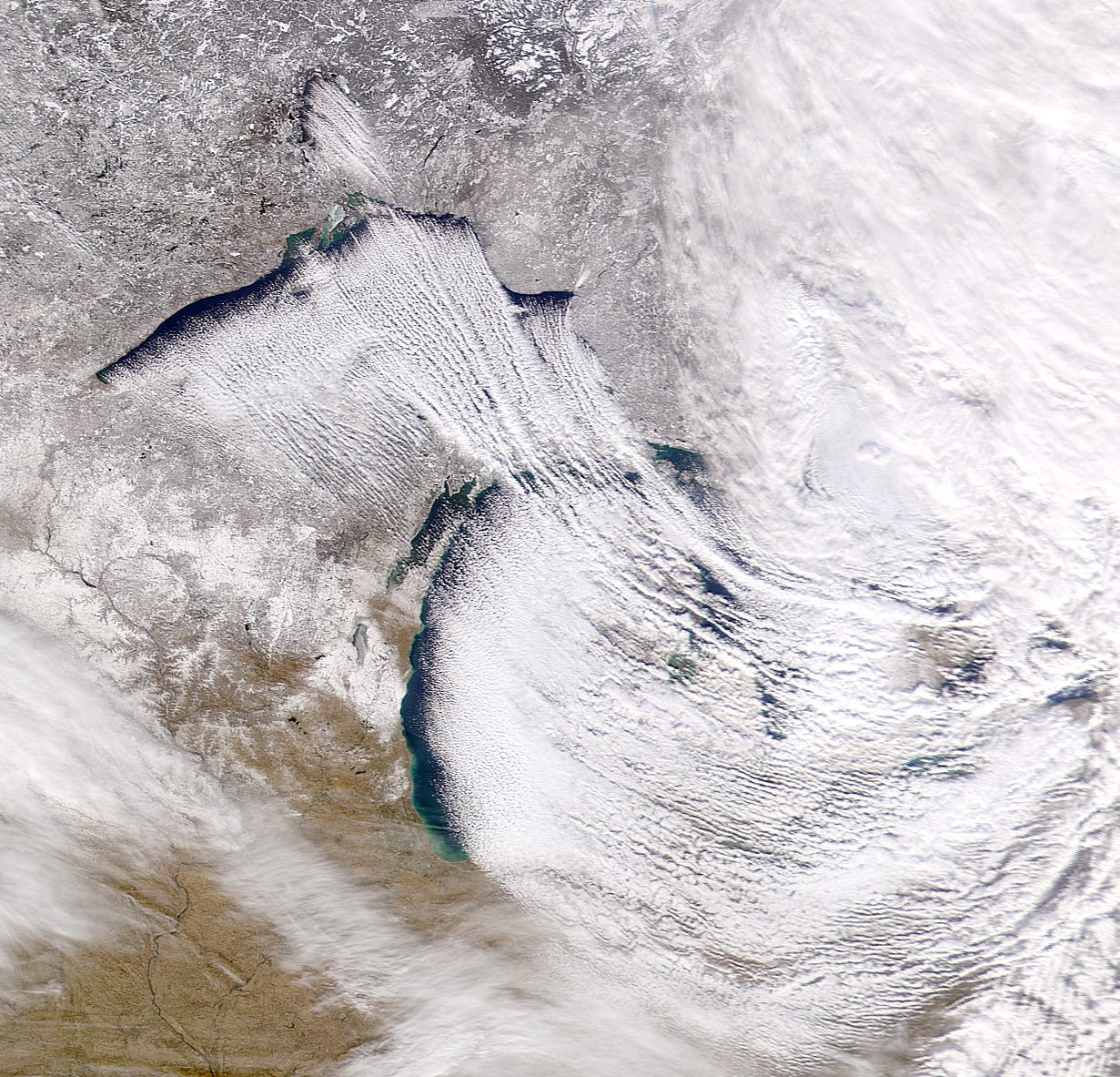
これらの湖から伸びている奇妙な雲は何でしょう?これらの雲は、暖かい水面上を移動する冷たい空気によって発生し、湖水効果雪の帯を生み出します。湖水効果雪を降らせる、湿った暖かい空気の上昇帯と、下降する冷たい空気の澄んだ帯が交互に現れます。冬の間、このような帯は、わずか100キロメートル離れた風上地域よりも数百センチメートルも多くの雪を生み出すことがあります。2000年12月5日のこの湖水効果雪の際には、アメリカ合衆国ミシガン州のほぼ全域が雪に覆われました。スペリオル湖とミシガン湖上を吹く冷たい北西の風が、この珍しい雲を作り出しました。上の画像は、NASAのSeaWiFS衛星で撮影されたものです。
原文(English)
What are those strange clouds stretching out from these lakes? The clouds are caused by cold air moving over a warm water and result in bands of lake-effect snow. The rising bands of moistened, warmed air that drop lake-effect snow alternate with clear bands of falling cold air. During a winter, such bands can create hundreds of centimeters of snow more than upwind areas only a hundred kilometers away. During this lake-effect snowfall of 2000 December 5, practically all of the state of Michigan, USA got covered. A cold northwesterly wind over Great Lakes Superior and Michigan created the unusual clouds. The above image was taken with NASA's SeaWiFS satellite.
\ この感動を宇宙仲間にシェア /
宇宙をXでシェア
© NASA / APOD