
🚀 宇宙の記憶・カレンダー検索
🚀 象徴的な写真:
APOD第1回
🚀 創造の柱
🚀 スピリット火星着陸
🚀 ハッブル超深宇宙
🚀 地球へようこそ|ブルー・マーブル
🚀 エンケラドス
🚀 ベテルギウス
🚀 火星着陸
🚀 青い夕焼け
🚀 冥王星のハート
🚀 皆既日食
🚀 アースライズ再構築
🚀 ブラックホール
🚀 ウェッブ初画像
🚀 アポロ11着陸
APOD30周年(2025年6月16日)
ポツダム重力ポテト
The Potsdam Gravity Potato
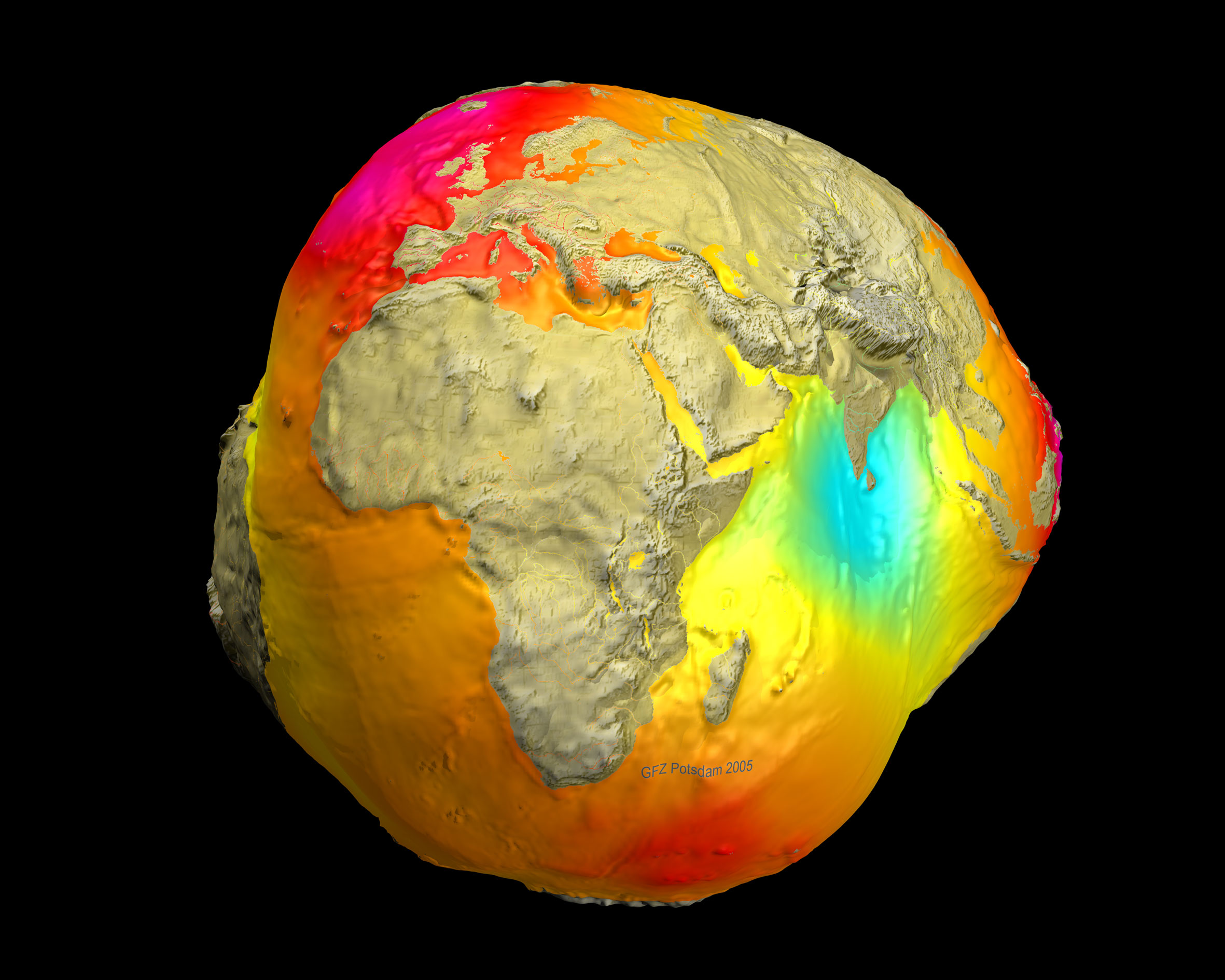
地球上の場所によって重力が異なるのはなぜでしょうか?その理由は不明な場合もあります。地球表面をより深く理解するために、周回衛星GRACEとCHAMPによる高感度な測定データを用いて、地球の重力場の地図が作成されました。これらのデータを研究するセンターがドイツのポツダムにあること、そしてその結果として地球がジャガイモのような形に見えることから、このジオイドは「ポツダム重力ジャガイモ」と呼ばれています。この地図上で赤色で示されている高い領域は、重力が通常よりわずかに強い領域を示し、青色の領域は重力がわずかに弱い領域を示しています。ポツダム重力ジャガイモに見られる多くの起伏は、北大西洋中央海嶺やヒマラヤ山脈などの地表地形に起因するものですが、そうでないものもあり、それらは地表下の異常に高い、あるいは低い密度に関連している可能性があります。このような地図は、変動する海流や氷河の融解など、地球表面の変化を較正するのにも役立ちます。上記の地図は2005年に作成されたものですが、より新しく、より高感度な地球の重力図が2011年に作成されました。APOD 2015壁掛けカレンダー発売中
原文(English)
Why do some places on Earth have higher gravity than others? Sometimes the reason is unknown. To help better understand the Earth's surface, sensitive measurements by the orbiting satellites GRACE and CHAMP were used to create a map of Earth's gravitational field. Since a center for studying these data is in Potsdam, Germany, and since the result makes the Earth look somewhat like a potato, the resulting geoid has been referred to as the Potsdam Gravity Potato. High areas on this map, colored red, indicate areas where gravity is slightly stronger than usual, while in blue areas gravity is slightly weaker. Many bumps and valleys on the Potsdam Gravity Potato can be attributed to surface features, such as the North Mid-Atlantic Ridge and the Himalayan Mountains, but others cannot, and so might relate to unusually high or low sub-surface densities. Maps like this also help calibrate changes in the Earth's surface including variable ocean currents and the melting of glaciers. The above map was made in 2005, but more recent and more sensitive gravity maps of Earth were produced in 2011. Now Available: APOD 2015 Wall Calendars
\ この感動を宇宙仲間にシェア /
宇宙をXでシェア
© NASA / APOD