
🚀 宇宙の記憶・カレンダー検索
🚀 象徴的な写真:
APOD第1回
🚀 創造の柱
🚀 スピリット火星着陸
🚀 ハッブル超深宇宙
🚀 地球へようこそ|ブルー・マーブル
🚀 エンケラドス
🚀 ベテルギウス
🚀 火星着陸
🚀 青い夕焼け
🚀 冥王星のハート
🚀 皆既日食
🚀 アースライズ再構築
🚀 ブラックホール
🚀 ウェッブ初画像
🚀 アポロ11着陸
APOD30周年(2025年6月16日)
HI4PI:水素の空
HI4PI: The Hydrogen Sky
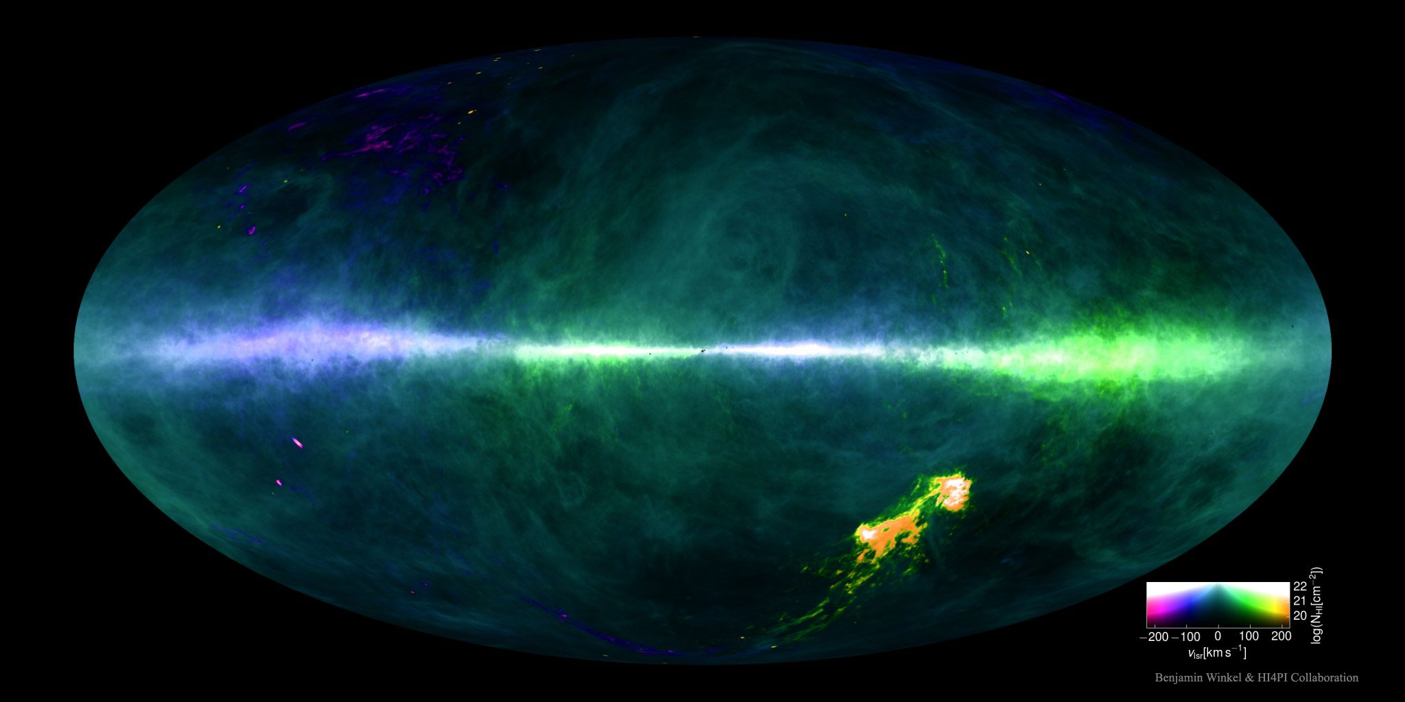
天の川銀河のガス雲はどこにあり、どこへ向かっているのでしょうか?この疑問に答えるため、宇宙で最も豊富なガスである水素の、最高解像度の新しい全天マップが完成し、その基となるデータとともに最近公開されました。上に示した全天マップは、水素の21cm輝線によるもので、明るさで存在量、色で速度を示しています。私たちに向かってくる低視線速度は人工的に青色で、私たちから遠ざかる低視線速度は緑色で示されています。中央の帯は天の川銀河の平面であり、右下の明るい点は隣接するマゼラン雲です。HI4PIマップは、ドイツの北部にあるエッフェルスベルク100メートル電波望遠鏡と、オーストラリアの南部にあるパークス64メートル電波望遠鏡(通称「ザ・ディッシュ」)による100万回以上の観測データから構成されています。このマップの詳細な情報は、天の川銀河における星形成と星間ガスについて人類により多くの情報を提供するだけでなく、この局所的なガスが外部宇宙を観測する際にどれだけの光を吸収する可能性が高いかについても教えてくれます。地図上の多くの詳細は、まだ十分に解明されていない。
原文(English)
Where are the Milky Way's gas clouds and where are they going? To help answer this question, a new highest-resolution map of the sky in the universe's most abundant gas -- hydrogen -- has been completed and recently released, along with its underlying data. Featured above, the all-sky map of hydrogen's 21-cm emission shows abundance with brightness and speed with color. Low radial speeds toward us artificially colored blue and low radial speeds away colored green. The band across the middle is the plane of our Milky Way Galaxy, while the bright spots on the lower right are the neighboring Magellanic Clouds. The HI4PI map collects data from over one million observations with the northern Effelsberg 100-Meter Radio Telescope in Germany and the southern Parkes 64-Meter Radio Telescope in Australia, also known as "The Dish". The details of the map not only better inform humanity about star formation and interstellar gas in our Milky Way galaxy, but also how much light this local gas is likely to absorb when observing the outside universe. Many details on the map are not yet well understood.
\ この感動を宇宙仲間にシェア /
宇宙をXでシェア
© NASA / APOD