
🚀 宇宙の記憶・カレンダー検索
🚀 象徴的な写真:
APOD第1回
🚀 創造の柱
🚀 スピリット火星着陸
🚀 ハッブル超深宇宙
🚀 地球へようこそ|ブルー・マーブル
🚀 エンケラドス
🚀 ベテルギウス
🚀 火星着陸
🚀 青い夕焼け
🚀 冥王星のハート
🚀 皆既日食
🚀 アースライズ再構築
🚀 ブラックホール
🚀 ウェッブ初画像
🚀 アポロ11着陸
APOD30周年(2025年6月16日)
北米における寒波の到来が遅れている。
Cold Weather Delayed over North America
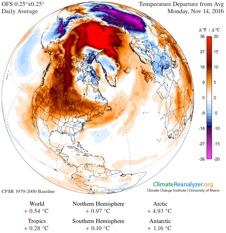
北アメリカ北部がなぜこんなに暖かいのでしょうか?例年この時期(11月中旬)の平均気温は、30度も低いのが普通です。ヨーロッパでは同様の温暖化は見られません。その一因として、カナダ上空に異常に大きく安定した高気圧域が形成され、通常は冷たい北極の空気を遮断していることが挙げられます。あらゆる気象パターンの根本的な原因は一般的に複雑ですが、この持続的なカナダ高気圧域は、昨冬に発生した太平洋中部の海面水温が平均よりも高かったこと(エルニーニョ現象)と関連しているという憶測があります。しかし、北米の人々は、この暖かさが続く間は楽しむべきでしょう。今後1~2週間で、太平洋中部で現在記録されている平均よりも低い気温(ラニーニャ現象)が、北米の風や気温のパターンに影響を与え始める可能性があります。APODギャラリー:2016年スーパームーンベスト(I)、2016年スーパームーンベスト(II)
原文(English)
Why is it so warm in northern North America? Usually during this time of year -- mid-November -- temperatures average as much as 30 degrees colder. Europe is not seeing a similar warming. One factor appears to be an unusually large and stable high pressure region that has formed over Canada, keeping normally colder arctic air away. Although the fundamental cause of any weather pattern is typically complex, speculation holds that this persistent Canadian anticyclonic region is related to warmer than average sea surface temperatures in the mid-Pacific -- an El Ni�o -- operating last winter. North Americans should enjoy it while it lasts, though. In the next week or two, cooler-than-average temperatures now being recorded in the mid-Pacific -- a La Ni�a -- might well begin to affect North American wind and temperature patterns. APOD Galleries: Best of Supermoon 2016 (I), Best of Supermoon 2016 (II)
\ この感動を宇宙仲間にシェア /
宇宙をXでシェア
© NASA / APOD