月の南極の影
Shadow at the Lunar South Pole
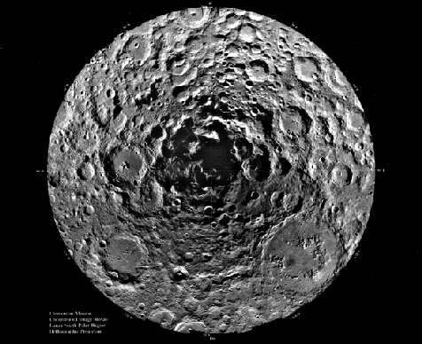
1994年、宇宙探査機クレメンタインは月周回軌道上で70日間を過ごし、月の表面をマッピングしました。上に示したのは、クレメンタインが撮影した1500枚の画像から作成された、月の南極を中心とした非常に詳細な合成画像です。上半分は地球に面した月面、下半分は月の裏側を示しています。画像からは、南極のすぐ近くに大きな窪みがあることが明らかになりました。これはおそらく彗星か小惑星の衝突によってできたものと考えられます。衝突地点付近の影の領域は広範囲に及び、永久に残る可能性があり、彗星由来の水を氷として閉じ込めるのに十分な低温の領域を作り出していると考えられます。
原文(English)
In 1994, the space probe Clementine spent 70 days in lunar orbit mapping the Moon's surface. Shown above is a dramatically detailed composite view centered on the Moon's South Pole constructed from 1500 Clementine images. The top half shows the part of the Moon which faces the Earth while the bottom half is the lunar Farside. The images reveal a major depression very near the South Pole itself, probably caused by the impact of a comet or asteroid. The shadow region near the impact site is extensive and may be permanent - creating an area cold enough to trap water of cometary origin as ice.
\ この感動を宇宙仲間にシェア /
宇宙をXでシェア
© NASA / APOD