地球上のハリケーンの進路
Hurricane Paths on Planet Earth
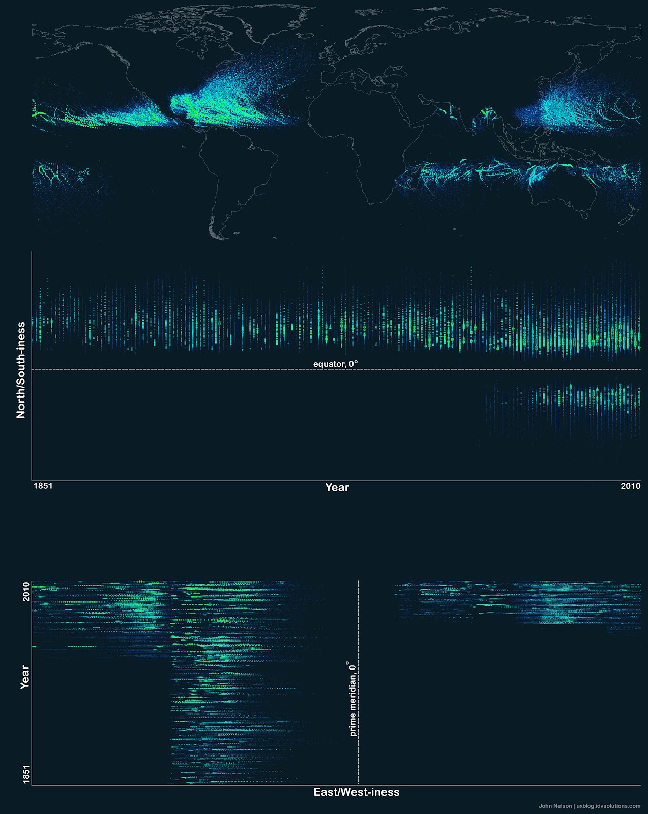
ハリケーンについて心配する必要があるでしょうか?それを知るには、過去にハリケーンがどこを通ったかを知ることが役立ちます。上の地球地図は、1851年以降に報告されたすべてのハリケーンの経路を示しています。印象的ではありますが、過去に遡るほどデータには不完全さが増していきます。上の地図は、ハリケーン(発生場所によってはサイクロンや台風と呼ばれることもあります)が通常、水上で発生することを視覚的に示しています。これは、暖かい水の蒸発がハリケーンにエネルギーを与えることを考えると理にかなっています。また、地図は、コリオリ効果が赤道でゼロになるため、ハリケーンが循環するにはコリオリ力が必要であるため、ハリケーンが地球の赤道を越えたり、赤道のすぐ近くで発生したりすることは決してないことを示しています。コリオリ力はまた、ハリケーンの経路が赤道から弧を描くようにする原因にもなります。不完全なデータによって長期的な傾向が不明瞭であり、ハリケーンの発生頻度は依然として研究対象となっているものの、過去20年間で北大西洋におけるハリケーンの発生頻度と勢力が平均的に増加しているという証拠が蓄積されつつある。天文学教師募集:NASAのNITARPに参加しよう
原文(English)
Should you be worried about hurricanes? To find out, it is useful to know where hurricanes have gone in the past. The above Earth map shows the path of every hurricane reported since 1851, Although striking, a growing incompleteness exists in the data the further one looks back in time. The above map graphically indicates that hurricanes -- sometimes called cyclones or typhoons depending on where they form -- usually occur over water, which makes sense since evaporating warm water gives them energy. The map also shows that hurricanes never cross -- or even occur very near -- the Earth's equator, since the Coriolis effect goes to zero there, and hurricanes need the Coriolis force to circulate. The Coriolis force also causes hurricane paths to arc away from the equator. Although incompleteness fogs long term trends and the prevalence of hurricanes remains a topic of research, evidence is accumulating that hurricanes are, on the average, more common and more powerful in the North Atlantic Ocean over the past 20 years. Astronomy Teachers Wanted: Join NASA's NITARP
\ この感動を宇宙仲間にシェア /
宇宙をXでシェア
© John Nelson,
IDV Solutions / APOD